
Drone inspections improve high voltage line maintenance planning when they are treated as a decision input rather than a replacement for engineering judgment. Their value is not simply that they capture images from the air. The practical advantage is that they make it easier to see, document, compare, and rank conditions across long or difficult-to-access line corridors before crews, equipment, and outage windows are committed.
A well-run inspection program can reveal damaged conductor strands, cracked or contaminated insulators, corroded fittings, loose hardware, clearance problems, encroaching vegetation, and access constraints. More importantly, it can connect those observations to asset location, defect severity, prior findings, and maintenance history. That connection allows maintenance work to be planned around risk, consequence, and repair urgency rather than around incomplete patrol notes or the most recently reported issue.
Better planning starts with better visibility of the line corridor
Traditional ground patrols remain necessary, especially where detailed physical examination or repair is required. However, a ground-based view is often limited by terrain, weather, road access, vegetation, and the angle from which the asset can be seen. A defect on the upper side of a crossarm, the underside of a conductor fitting, or the top of an insulator string may not be visible from the ground.
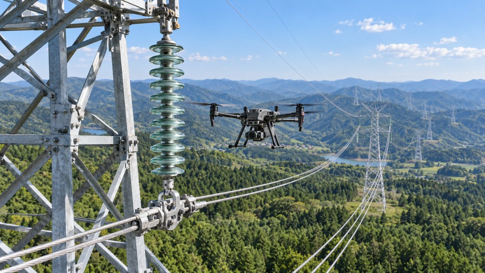
Drone-based inspection gives planners a more complete visual record of the asset and its surroundings. High-resolution still images can support close review of hardware, insulator assemblies, conductor condition, pole or tower structure, and right-of-way encroachment. Thermal imaging, where appropriate and operated under suitable conditions, can add another layer by helping identify unusual heat patterns that may justify a closer engineering review.
The important distinction is between finding something unusual and proving the cause of a fault. Aerial imagery can identify a condition that needs attention, but it does not automatically establish the root cause or repair scope. For example, a darkened connection, damaged insulator surface, or visible conductor irregularity may require a follow-up inspection by a qualified specialist. Maintenance planning improves when the drone inspection creates a reliable work queue for those follow-up activities.
From aerial observations to a risk-based maintenance plan
Drone inspections are most useful when each observation is converted into structured maintenance information. A folder of images may be useful for reference, but it does not reliably support prioritization. Each finding should be linked to the relevant line, structure, circuit, component type, location reference, date, image evidence, condition description, and initial severity category.
That structure allows planning teams to separate immediate hazards from conditions that should be monitored or addressed during a planned maintenance window. It also prevents a common failure: treating every visible defect as equally urgent. A small corrosion area on a non-critical fitting and a compromised component on a heavily loaded corridor may both deserve action, but they do not necessarily demand the same schedule, crew type, access arrangement, or outage decision.
A practical priority decision usually considers several questions together:
- What component is affected, and what role does it play in mechanical or electrical reliability?
- Is the observed condition stable, progressing, or likely to worsen quickly under normal operation?
- Could the condition create a public safety, worker safety, fire, outage, or equipment-damage risk?
- What is the consequence if the asset fails before the next planned intervention?
- Can the condition be corrected while energized, during a scheduled outage, or only after a detailed field assessment?
- Does access require vegetation work, special lifting equipment, road permits, or environmental controls?
This approach changes the role of inspection. Instead of generating a long defect list, the inspection supports an executable plan: which locations need confirmation, what work package is needed, where an outage is justified, and which tasks can be grouped geographically to reduce repeated site mobilization.
Where drone data has the strongest maintenance value
The strongest use cases are usually those where visibility, access, and repeatability are difficult. Long transmission corridors, mountainous routes, water crossings, dense vegetation, remote structures, and areas with restricted ground access are obvious examples. The benefit can also be significant in more accessible areas when a line has a large number of similar assets that need consistent condition documentation.
Conductor and hardware condition
Aerial images can help identify visible strand damage, spacer or damper concerns, hardware corrosion, missing components, loosened fittings, and signs of mechanical wear. The inspection should use a flight plan that captures relevant angles rather than relying on broad overview shots. For maintenance planning, an image is useful only if it allows the reviewer to identify the component, assess its condition, and locate it accurately enough to prepare follow-up work.
Insulators and associated assemblies
Insulator strings, polymer insulators, clamps, arcing horns, and related components often require close visual review. Drones can provide repeatable coverage of these assemblies without placing people near elevated energized equipment for every preliminary check. Surface contamination, physical damage, alignment concerns, and signs of flashover exposure can be documented for comparison over time.
Image quality matters here. Motion blur, poor lighting, excessive distance, and inconsistent inspection angles can make a condition impossible to classify. A technically capable aircraft cannot compensate for an inspection method that does not define what needs to be seen.
Vegetation and clearance risks
Vegetation management is often planned separately from line hardware maintenance, but the risks are connected. Drone surveys can show growth near conductors, access routes blocked by vegetation, unstable branches near structures, and areas where ground crews may need clearing before repair work begins. When this information is available early, vegetation work can be coordinated with inspection follow-ups or planned repairs instead of becoming a last-minute delay.
Structure, access, and worksite preparation
Maintenance planning does not begin when a crew arrives at the asset. It begins with knowing whether the structure can be reached safely and what equipment will be required. A drone survey can document damaged access roads, steep terrain, nearby obstacles, water crossings, landing zones, and structural conditions that affect the work method. This is particularly useful when an apparent minor repair requires more preparation than the defect description initially suggests.
Choose the inspection method around the maintenance question
Not every line needs the same drone payload, flight pattern, or review process. The right setup depends on what decisions the inspection must support. A general corridor survey and a close-up component inspection are different jobs. Combining them without a clear purpose often produces too much imagery of the wrong kind.
For repeated inspections, consistency is more valuable than visual novelty. Using comparable viewpoints, naming rules, defect categories, and location references makes it possible to determine whether a condition is changing. Without that consistency, teams may have images from multiple dates but no dependable way to compare them.
The workflow that turns a flight into maintenance action
A useful drone program has a clear path from inspection request to closed maintenance record. The process does not need to be complex, but responsibilities must be defined before flights begin.
- Set the inspection objective. Define the assets, components, corridor sections, and conditions that must be assessed. This prevents flights from becoming broad visual surveys with no maintenance decision attached.
- Prepare the asset and risk information. Use current line maps, structure identifiers, known defects, terrain constraints, weather limits, and operating restrictions to build the flight plan.
- Capture evidence to a repeatable standard. Record images and observations with enough detail to identify the structure and component. Include overview images when they help establish context.
- Review and classify findings. Separate normal conditions, monitoring items, maintenance candidates, and conditions requiring urgent escalation. The review criteria should be agreed in advance.
- Validate high-consequence findings. Use engineering review, closer inspection, or field confirmation where image evidence alone cannot establish repair scope or operational risk.
- Build work packages, not isolated tasks. Group work by location, access method, outage needs, component type, and crew capability where doing so does not delay urgent corrections.
- Close the loop after maintenance. Link completed repairs to the original inspection finding. This creates a condition history that makes future inspections more meaningful.
The classification stage deserves particular attention. A system that labels every finding “critical” will quickly lose credibility and overload maintenance capacity. A system that uses vague categories without evidence may allow serious conditions to remain in the backlog. Clear examples for each classification level, supported by image references and component descriptions, make review decisions more consistent.
Safety gains depend on operating discipline
Drone inspections can reduce the need for preliminary climbing, helicopter observation, or repeated travel into hazardous terrain. That reduction can improve exposure control, but only if the flight operation itself is integrated into the site safety system. Airspace awareness, weather assessment, electromagnetic interference considerations, line proximity controls, battery management, emergency recovery planning, and communication with line operations all need defined procedures.
There is also a less obvious safety benefit: better planning reduces rushed work. When a maintenance crew arrives with accurate information about access, component condition, tools, lifting needs, and nearby hazards, fewer decisions have to be made under time pressure at the structure. The drone does not eliminate field risk; it helps remove uncertainty before field work starts.
Common mistakes that weaken the result
Using drones only after a problem is reported. Reactive flights can be useful, but they provide limited value for long-term maintenance planning. A repeatable inspection cycle creates a condition baseline and makes deterioration easier to identify.
Collecting images without an asset data model. Images saved by date or pilot name become difficult to retrieve when maintenance planning begins months later. Findings should be searchable by asset and component, not only by file name.
Assuming visual evidence equals diagnosis. A visible anomaly may be sufficient to prioritize a follow-up, but it may not reveal internal damage, electrical performance, or the correct repair method. Escalation rules should account for that limit.
Ignoring data review capacity. Large surveys can generate more footage than a team can evaluate promptly. The inspection scope should match the available review process, and automated detection tools should support, not replace, informed verification.
Separating inspection records from maintenance records. When inspection findings and completed work are stored in different systems with no link between them, the organization loses the ability to see whether recurring defects are being resolved or merely rediscovered.
What to confirm before starting a drone inspection program
Begin with the maintenance decisions the program needs to improve. Identify whether the immediate problem is defect visibility, difficult access, inconsistent documentation, vegetation planning, delayed work scoping, or limited ability to compare asset condition over time. That answer determines the inspection design and prevents investment in imagery that does not change field decisions.
Next, define the threshold for action. Maintenance planners need to know what image quality is acceptable, what conditions trigger engineering review, when a ground or climbing inspection is required, and who can approve a change in maintenance priority. These rules are more important than selecting the most feature-rich aircraft.
Finally, make the results usable across the asset lifecycle. Inspection data becomes more valuable when it is connected to work history, component types, outage planning, and recurring condition patterns. Intelligence platforms such as the Global Power & Electrical Grid Matrix can help teams follow broader developments in grid equipment, digital inspection practices, and transmission priorities, but local asset records and disciplined review remain the foundation of a workable maintenance program.
Drone-enabled inspection is most effective when it helps answer a practical question: what should be repaired, verified, monitored, or prepared next? When aerial evidence is collected consistently and translated into risk-based work decisions, high voltage line maintenance becomes more planned, more defensible, and less dependent on incomplete visibility in the field.
Related News
- How drone inspections improve high voltage line maintenance planningOct 14, 2026High voltage line maintenance planning improves with drone inspections that reveal defects, access risks, and vegetation issues for safer, faster, risk-based repairs.
- When should high voltage power line maintenance be brought forward?Oct 13, 2026High voltage power line maintenance: learn when worsening insulation, thermal anomalies, recurring faults, weather exposure, or load changes demand earlier action.
- How to size medium voltage cable systems for industrial loadsSep 30, 2026Medium voltage cable systems: learn how to size industrial feeders for ampacity, voltage drop, fault duty, installation conditions, and future expansion.
- What Cable Voltage Rating Should Be Specified in a Tender?Sep 24, 2026What cable voltage rating should a tender specify? Learn how U0/U (Um), earthing, fault duration, standards, and surge duty shape a compliant cable requirement.
Related News
- 00
0000-00
How energy prices affect the cost of decarbonizing industrial processes - 00
0000-00
How SCADA grid automation supports remote feeder fault isolation - 00
0000-00
How much does arc-resistant construction add to switchgear prices? - 00
0000-00
How a decarbonization process framework turns targets into action - 00
0000-00
How variable frequency drives cut energy use in water treatment